
Meet the Malden River
About the River
The Malden River is resilient. Despite being buried underground, abused by industry, and hidden from the community, the Malden River is an ecological home to aquatic life.
When the community realizes their treasure, the Malden River will flourish.
The Malden River is part of the larger Mystic River watershed and is currently flanked by the towns of Malden, Medford, and Everett. The 2.3-mile long river meandered over the land, and was often fished for Alewife and Blueback Herring. The river landscape appeared significantly different than it does today. Once a tidal river bordered by salt marshes and tidal flats, with the creation of the Amelia Earhart Dam, the river is now freshwater.
Malden River 1936 | Courtesy of Malden Historical Society
Native American and Colonial Periods
The importance of these waterways to the region predates seventeenth century colonization. The Malden River and the Mystic River watershed made up a critical collection of waterways within the lands of the Massachusett tribe and the Pawtucket Confederacy of Indigenous tribes. The watershed and its tributaries provided food, transportation networks, and opportunities for trading among the Pawtucket, Massachusett and Wampanoag peoples, and eventually with European colonists. For the next two hundred and fifty years, the Mystic River watershed shaped colonial life as a source of food and a foundation of early industrial development.
From Marshes to Industry
While the rivers initially supported fishing and farming, industrial uses grew dominant by the nineteenth century. Railroads snaked along riverbanks, and mills and factories polluted the rivers, groundwater and soil. Engineering advances of the nineteenth and twentieth century restricted the flow of waterways into canals and culverts, burying streams, ponds, and other waterways in the watershed. Salt marshes were filled and paved over for new roads and industries. In the process, the Malden River disappeared into an industrial landscape.
The Path of the Malden River Today
Malden River 2015 | Photo Credit: David Mussina
The Malden River has shaped development in Malden and in communities throughout its watershed. The river originates north of Malden at Spot Pond in Stoneham, trickling east as Spot Pond Brook through the Middlesex Fells Reservation. After crossing into Melrose, the stream is diverted into the West Wyoming Avenue culvert. From there it continues below the streets of Melrose, resurfacing just south of the Wyoming Hill commuter rail station. From there, the brook roughly parallels the Commuter Rail train tracks into Malden, past Oak Grove where the Orange Line begins. Nearby that station at Winter Street, the river is diverted into a culvert that flows through a residential neighborhood, Cotymore Lea Park, and underneath downtown Malden until it reemerges south of Anthony’s Italian Restaurant near the intersection of Canal Street and Charles Street. Along the way, the waterway is fed by rainwater collected by other underground channels that flow from the hills to the point.
Malden River Aerial 2020 | Photo Credit: Greig Cranna
Just south of the Medford Street bridge, the river widens and continues south at which point it joins Little Creek, marking the boundary between Malden and Medford, and to the east, Everett. The river continues out of Malden, separating Everett from Medford until it empties into the Mystic River, which connects to Boston Harbor and, eventually, to Massachusetts Bay.
Malden River Trails
Riverside trails are widely appreciated venues for exercise, birding, fishing, family outings, and more. A handful of organizations have been working hard to create a connected trail network along the Malden River. This Trails and Paths map uses information gathered from the Metropolitan Area Planning Council (MAPC). It is thought to be the most comprehensive listing of trails (and plans for trails) available. Use this map to plan your own outing along the banks of the Malden River!

Scan for phone map or Download PDF.

Scan the QR code to get TrailLink on your phone
Environmental Justice Around the Malden River
Industrial development along the Malden River led to environmental degradation. Residential areas near the river provided close proximity to jobs while threatening negative health impacts. These threats were exacerbated by discriminatory residential lending policies and practices, which continue to impact residents along the Malden River today. In the 1930’s the Homeowners Loan Corporation designated the areas surrounding the Malden River to be Hazardous, or “Redlined.” Today, those areas are considered Environmental Justice communities because their residents earn low incomes, are isolated due to the language they speak, and are people of color.[1]
Furthermore, as the Mystic River Watershed research has shown, people in these areas today are more prone to heat exposure because of a lack of tree canopy and an overabundance of impervious surface.[1]
These trends, however, are starting to change. In 2017 Redfin listed the Edgeworth neighborhood that abuts the Malden River to the west to be the #1 hottest neighborhood in Greater Boston. Future efforts to improve the area will need to include strategies that mitigate displacement and ensure that benefits accrue to the people who have historically made this area their home.
[1] Mystic River Watershed Association. August 2020. MyRWA, Racial Justice and Covid-19: Why it’s Connected. Accessed October 12, 2020.
Source: Metropolitan Area Planning Council (MAPC). “Placemaking as a Catalyst for Change on the Malden River”
About the City of Malden
As a Gateway City, Malden was a historic industrial employment anchor in the Metro Boston region, where mills and factories such as the Boston Rubber Shoe Company and the Converse Rubber Company once utilized its network of streams, ponds, and the Malden River for power.
1796 map of Malden River prepared by Peter Tufts | Courtesy of “Images of America, Malden” Malden Historical Society
After years of industrial development and subsequent decline, Malden’s portion of the Malden River is bracketed by a sea of asphalt parking lots and light industrial businesses today that offer little to no river access, and exacerbate water quality and surface flooding risks through poor site design and stormwater management.
While the other two cities on the Malden River, Medford and Everett, have effectively leveraged recent large-scale redevelopment projects to introduce waterfront open space, pathways, and recreational amenities along lower reaches of the River, Malden has been overlooked in terms of community benefits, with very little public access to the river. Additionally, the characteristics that once made Malden attractive for early industrial development are directly linked to climate change vulnerabilities today. Flooding now threatens a large portion of the city’s low-lying areas as early as 2045 from multiple floodways, including the Malden River from the south and coastal flooding through Revere to the east.
Amelia Earhart Dam. The installation of the Amelia Earhart Dam in 1966, literally sealed the river’s future. Installed to prevent flooding in cities upriver, the dam prevented the tidal flow of fresh sea water and was installed with a faulty fish ladder virtually cutting off any migration of fresh sea life and turning the river from saltwater to freshwater.
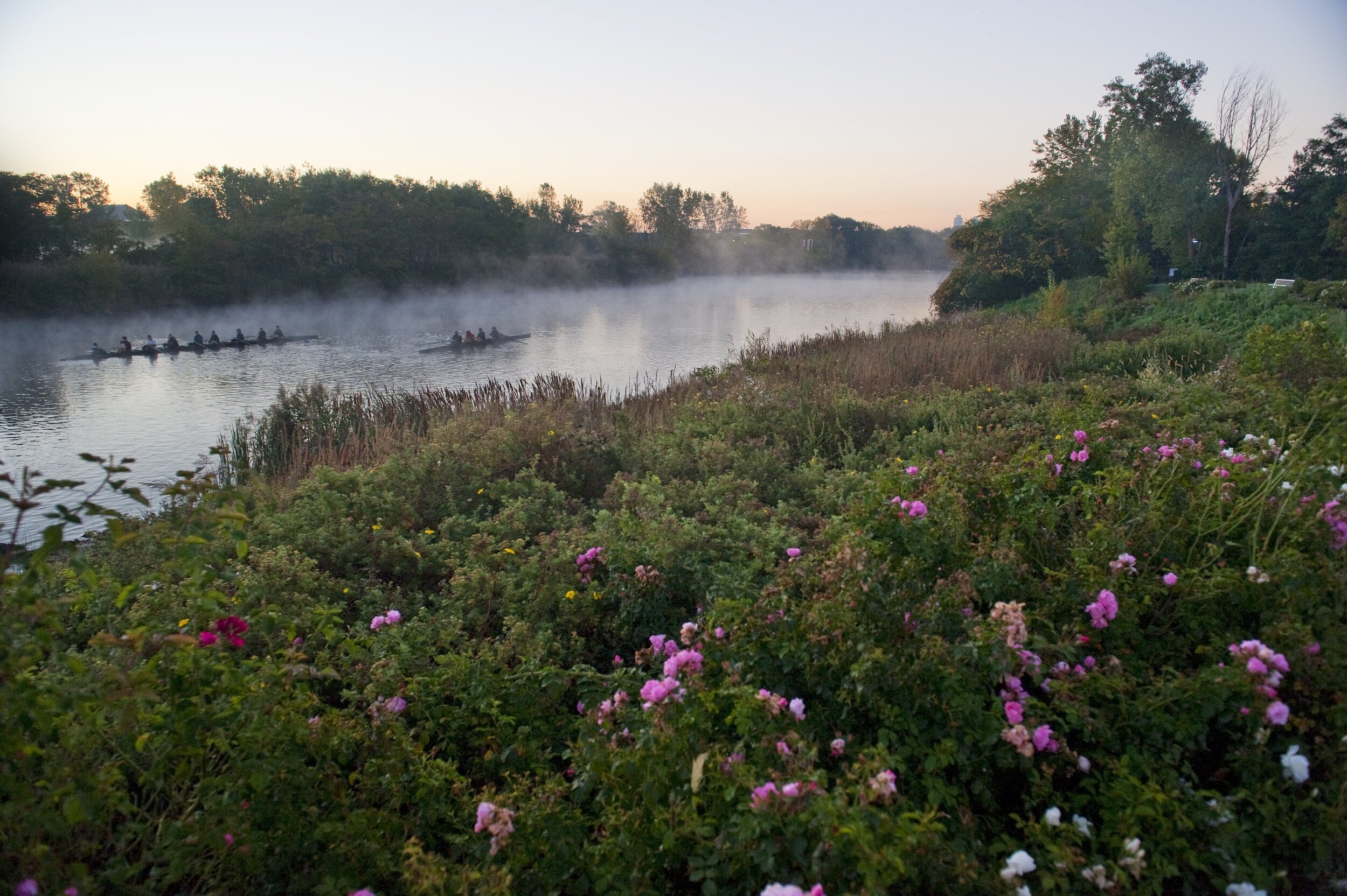
Cleared for Boating
Despite the history of contamination, no reliable public information existed about health risks posed by recreation on the river. The 2019 Human Health Risk Study for Boating on the Malden River showed results that were favorable for boating activities like canoeing, rowing, and kayaking.
“In the absence of a rigorous health risk analysis, ‘stay away from the water’ has been the logical and appropriate precautionary advice given to the public in prior years. This report represents a breakthrough for the recreational use of the river.”
- Kathy Vandiver, Massachusetts Institute of Technology’s Center for Environmental Health Sciences (MIT CEHS) and a volunteer at Friends of the Malden River
This study was designed to provide municipalities and organizations with the data needed to make informed decisions about legacy contaminants and boating on the Malden River. However, as with other Massachusetts urban waters, health risks on the Malden River that are associated with the increased bacterial levels after heavy rainfall events, still persist. Also algal blooms are possible. Boaters are advised to check the Mystic Daily Boating Advisory for the Malden River provided online by MyRWA.
The river sediments contain contaminants from legacy manufacturing of coal tar, rubber, steel, and numerous industrial chemicals, but exposure data indicating safe conditions for boating uses provided a turning point for the City of Malden to see the river as a potential public amenity.
Human Health Risk Study Analysis conducted by Gradient Corporation, Cambridge, MA. Assisted by Mystic River Watershed Association (MyRWA), MIT Center for Environmental Health Sciences (CEHS), Friends of the Malden River (FoMR), Mystic Valley Redevelopment Corporation, & Preotle Associates.
Water Quality and Boating Advisory
The Mystic River Watershed Association, together with the US Environmental Protection Agency (EPA), issues a water quality report card for the Mystic River Watershed each year. This includes the Malden River.
How safe is it to boat today? The Recreational Risk Assessment Project provides daily predictions for water quality conditions in the Mystic & Malden Rivers and Upper Mystic Lake at Shannon Beach. Available on the MyRWA website and via twitter @safemystic.
Banner Image: River’s Edge | Photo Credit: Greig Cranna